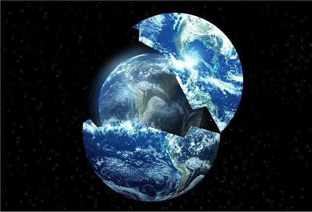
Editor’s note: The unseen continues to be seen as the energy “veils” continue to weaken/dissipate.
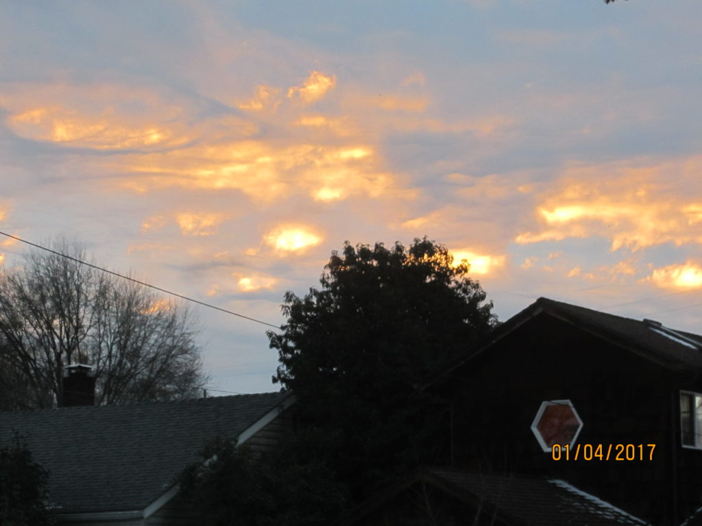
Taken last weekend from my kitchen window.
***
Your Official Go-To Blog on Ascension, New Earth, Spirituality, UFO's, Real History, New Technologies and All Things Alternative
Editor’s note: The unseen continues to be seen as the energy “veils” continue to weaken/dissipate.
Taken last weekend from my kitchen window.
***
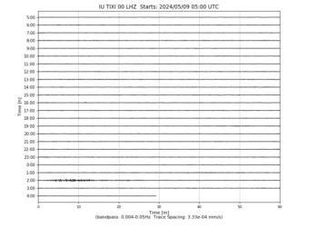
Update: Here’s the latest Heliplot for Tuski, Russia at 8:22pm PST. Compare it to the reading in the video. Very interesting.
Makia Freeman, Contributor
Waking Times
Standing Rock 2017 will continue to be an issue. The fight of the Native American Indian tribes, environmentalists and the water protectors (protestors) is not over. Although the Army Corps of Engineers announced on Sunday December 4th, 2016, that it would not be granting the DAPL easement access, there is nothing to stop the oil company from disobeying that and moving forward anyway. After all, the amount they would have to pay in fines in insignificant next to the lost revenue they are experiencing from the delay of the project. The announcement offered temporary relief, but the battle is not over. Some at the camps have stated that the announcement was propaganda to lull people into a false sense of security. You can expect Standing Rock 2017 to be just as newsworthy as Standing Rock 2016. Before going further, however, it is worth revisiting the legal facts of the Standing Rock / DAPL issue, since there was so much emotion, disinformation and confusion surrounding it.
First we need to understand the background. In 1851, the Laramie Treaty was struck which outlined the territorial claims of 8 American Indian tribes including the Sioux. However 11 years later in 1862, after many years of broken promises by the US Government (treaty land not honored, food and supplies not delivered as promised), a war raged between members of the Dakota nation and the US military in southern Minnesota. In fact, December 26th marked the 154th anniversary of the largest mass execution in US government history, when 38 Dakota men were publicly hanged in Mankato, Minnesota. Around this time gold and other minerals were discovered on Treaty reservation land, so the US Government took back the land, dug for uranium and poisoned the aquifer and thus the drinking water of the people there (now incidentally the Sioux must pump the Missouri River to make their water drinkable). In 1890, a horrible massacre took place. At the Battle of the Wounded Knee (not a battle but a massacre), white man shot Lakota Sioux women and children and killed their buffalo. History.com describes it as follows:
“The conflict at Wounded Knee was originally referred to as a battle, but in reality it was a tragic and avoidable massacre … a brutal massacre … in which it’s estimated 150 Indians were killed (some historians put this number at twice as high), nearly half of them women and children. The cavalry lost 25 men.”
Clearly there has been a lot of mistrust, broken promises, theft, violence and murder in the past. From the American Indian point of view, the DAPL is the black snake they have prophesized about which threatens their livelihood and lives. Those supporting the DAPL have made several claims substantiating why they believe it’s right, fair and legal. Let’s take a closer look at their claims.
Continue reading here.
Christina Sarich, Staff Writer
Waking Times
Humans have long thought themselves to be the smartest animals on the planet, but evidence continues to reveal that even with little shared DNA – animals are catching up, and perhaps even surpassing our own evolutionary intelligence.
Some philosophical perspectives suggest that this anthropomorphic egocentrism is misplaced, since all creatures, not just people have ‘mind,’ which is capable of evolving toward higher levels of consciousness. We share a quarter of our DNA, after all, with a single grain of rice, but there is something even more intelligent in our design, and many believe it permeates everything.
The Buddhists and Taoists regularly call for us to be mindful of all sentient beings, while the suppositions of panpsychism, the view that mind (psyche) is everywhere (pan), reaches back into ancient Greece and the teachings of Miletus and Plato.
Terrence McKenna supposes that the Universal psyche has been given an extra push overtime. He theorizes that animals moved to grasslands as the North African jungles receded after the ice age. These animals grazed on whatever they could find, including psilocybin-containing mushrooms growing in the dung of ungulate herds. McKenna suggests that the psychedelics in the animals’ diets helped to create synesthesia, and then language, followed by additional higher-intelligence skill sets.
Continue reading “Major Shifts of Consciousness Observed Throughout Animal Kingdom”
♥♥♥
Aliyah Marr
I am going to discuss the vision I had regarding how the old paradigm can transition into a new paradigm easily, safely, joyfully. The vision I had is that all the organizations in which people live and work — all the ones that they have come to depend upon, that they would be confused and bereft if they were to suddenly disappear.
All the organizations can transform into their higher dimensional versions. And that transformation is initiated by a vibrational shift among the populace that gets them to the level which they can understand the transition and integrate it very easily into their hearts and minds and in their physical existence.
Let’s take these organizations one by one just as samples.
We see corporations turning into cooperatives being owned and operated by the people who are the employees. And therefore they have a vested interest in these organizations. Going to work is fun and inspiring; everyone works in the position that they are most challenged and inspired by and that they feel the best at. And they can easily move from position to position, according to what they desire at the time.
The army becomes the army corps of engineers. Instead of an underlying intent of destruction, its underlying intent transforms to construction— reconstruction. They still use the same organization, the same kind of hierarchy in the beginning of the transition, and that makes everyone feel comfortable and happy, but their underlying intent has completely changed. So the same organization can be used for construction instead of destruction. So that makes a very easy way to transform the army into a much higher dimensional entity.
The navy becomes the oceanographers whose job is to protect the ocean and to help restore it to pristine natural beauty. So each one of these things is its higher dimensional [version]; its underlying intent has changed. And that intent is aligned with the higher self of the Earth as well as the higher selves of all the humans and the other sentient beings and all the beings on Earth; that intent is aligned with the new Earth.
That is the transitional phase.
Money becomes a means of appreciation because everyone is starting to realize that they don’t have to work to live on the Earth; they don’t have to pay to live on the Earth. People don’t have a real need to be greedy or to have more than anyone else as a form of protection because survival-based thinking is replaced by inclusion and love, which is the higher dimensional version of the base-level programming.
The base-level programming of survival thinking is what supports the old matrix. The new matrix is based upon love and inclusion: higher dimensional. And it requires that everyone get on board with that kind of thinking. So money might be necessary in the transitional phase, but it is only going to be returned to its original intent, which is a medium of exchange. So it [will] help to “grease the wheels,” so to speak.
The vision that I have for the component of the New Earth that I want to create is an online as well as physical—it has physical versions of it—and it is basically a creative center, and people can volunteer to do work in different places according to the needs of those places. So, for instance, there is a village in Africa that needs a better supply of water. [The site would supply experts] who know how to supply water. So the village in Africa that needs water.
You have this huge internet community: I call it the ImagiNation. It is made up of [creative] people who have the ability to imagine a new future, to imagine different constructs, who can make new things. And with this new thinking and the new intent underlying everything, people understand that when they go to help someone else, that they will be provided for while they are there.
This village in Africa that needs a new water supply, people that are experts in this, or have a vision, they would go there, they would spearhead the project. The resources of the area would be used, the people that are the workers would be the [labor force] from the area, the tribe, the community.
Everything would be local as much as possible. And if companies had to come in to help with this they may be able to make money from this, but the primary purpose of this is to support the community.
These creative people would then be going from community to community; they would be able to travel and to be supported in these communities and be supported while they are there. Their reputation is their currency so the creative [experts] are known for what they do, and their reputation precedes them, and they are “hired” to do this, but they can live anywhere in the world according to what they want and what they can do.
I see this as a very easy and fun and enjoyable transition. We have the ability to do this; we need the support of our higher selves to anchor this into reality. We are holding the intent for this— the vision for this. We know that every part of society can be changed overnight; this [transition] can be like wildfire spreading across the Earth where people jump on board because it is so much fun.
It is so much more fun to create something than to destroy something. It is so much more fun to live in community and harmony than it is to be constantly battling with each other; at odds and having to eek out your existence or defend your property. That’s the old paradigm that no longer needs to exist.
So we are holding the space for this [vision] and as women we are bringing it through our bodies into the Earth. [Breathing] Bring it in… anchor it…”Let it be real” — that’s the phrase I am getting…”Let it be real.” Let the vision be real.
People with money are going to start to realize that they can turn around and support this instead of supporting what they are supporting. They can turn around and support the growth of the New Earth, now, because it is needed now. They have the contacts, they have the money; they can help make this transition much, much, much easier. We are asking them—their higher selves—to release, to release the greed, to release the need for self-protection. And to join the party.
***
Please share! You may copy and redistribute this material so long as you do not alter or edit it in any way, the content remains complete and you include this link: https://infiniteshift.wordpress.com
Editor’s note: Thanks to the authors, Michelle Walling and Gregg Prescott, for taking on this topic. I am so very ready to have my child educated in such a system and it is something I would very much get behind myself. Anyone else interested? Drop me a line!
Although the subjects discussed in the Urantia book build a good basic foundation for education, higher learning classes would expand into subjects that will allow children will be excited about attending school. Examples of these kinds of subjects are:
Math– Geometry is the basic building block of all life. Math will take on a whole new meaning and new ways of arithmetic along with fun ways to calculate will be taught.
Cosmic Science– Identity and placement of Universes in our cosmos and the difference between free willed Universes and non free-willed Universes.
Universal Science– How planets, moons, and stars are sentient beings and how they all work together to form solar systems and galaxies.
Universal History– The history of the Universe including civilizations and placement in the Cosmos.
Creation Science– The study of how everyone and everything is connected from one Creator and how we contribute to that creation.
Human History– DNA studies, human genetics, and the history of humanity from Lyra to today, including the social statistics, behaviors, and characteristics of all humans in our Universe.
Human Rights- Constitutional Law on freedom and the Golden Rule.
Sexual Relations– The responsibility behind merging energies with another human and teaching the ability to decide whether another human body is created.
Universal Language– Learning the language of light which is understood throughout the Universe.
Universal Law– Learning the importance of Universal Law and how it relates to all sentient beings.
Astrology – Learning how to read and fully understand your birthchart.
Astronomy – Understanding the importance of stars, planets and constellations. Learning how the stars can show us the cycles of time along with how they can be used for navigation.
Sixth Sense Studies– Developing all of your innate gifts.
Meditation– Guided classes on how to safely travel the Universe with your consciousness, learning new meditation techniques, developing new ones.
Exercise– Yoga, Tai Chi, etc.
Galactic Ambassador Training– How to become a galactic ambassador, spaceship flight training.
Healing– Methods for keeping the body clear of negativity (reiki, quantum touch, etc…), responsible thinking, service to others.
Gardening– How to grow organic food and hemp for cultivation, different forms of gardening such as hydroponics, permaculture, etc…
Technological and Industrial Sciences– How to make almost anything from hemp, 3d printing, free energy technology, encourage free thinking and non competitive invention
Environment– The true importance of being stewards of the earth by living on her without making footprints and healing the environment.
Recycling– Maximizing what has been created in the past into something sustainable.
Council of Elder training– With the elimination of government, a Council of Elders training program will be facilitated to ensure that future elders will always be working in humanity’s best interests.
Music– All forms of music including history, composition, symphonic band and concert, and voice.
UFO Research – Classes on the documentation of UFOs through night vision goggles, how to interact with them, sky mapping, UFOs in Art History, etc…
Creative arts– All forms of creativity including art, dance, drama, and writing.
Community– How to contribute economically to your community through barter, volunteering, and communal caregiving for all children. Creative culinary classes and decorating houses for energy flow could be subjects.
Life Path Development – Helping people find their life path, based on their astrological charts, personal interests and past life experiences.
Spiritual Psychology– Learning how the body, mind, soul and spirit interact. Dream analysis, dream journals, counseling methods, past life regression techniques are included in this genre.
To read the article in its entirety, click here.
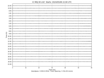
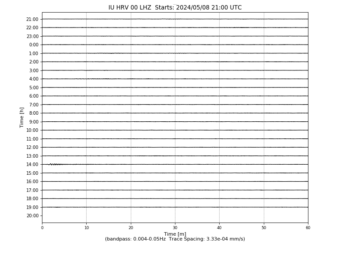
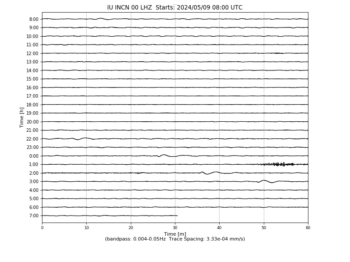
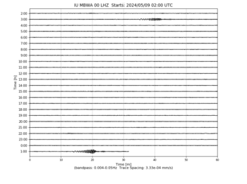
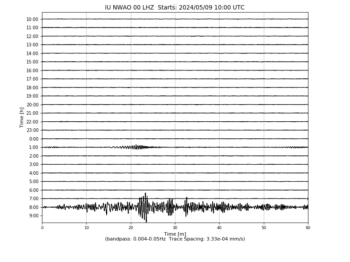
Seismograms may take several moments to load. Click on a plot to see larger image.
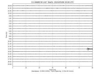
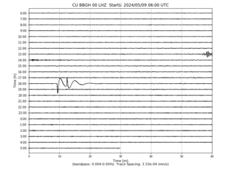

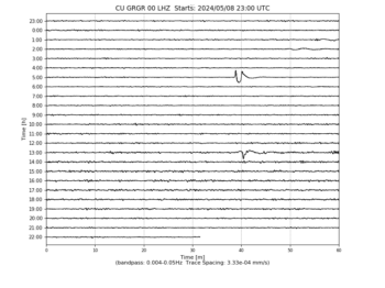
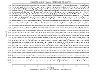
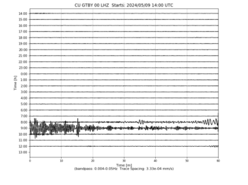
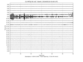
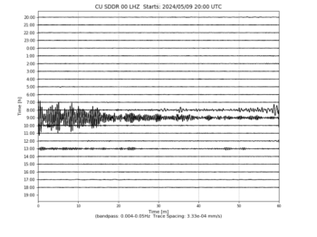

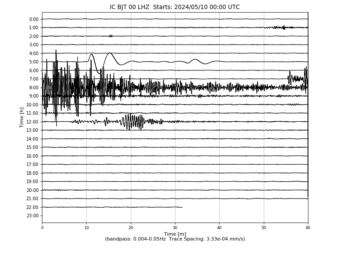

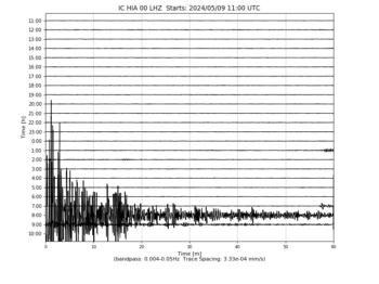

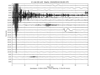
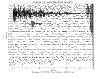


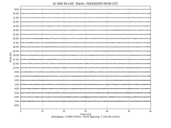
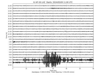
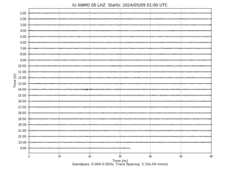
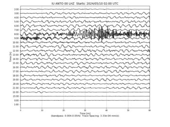
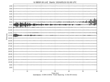
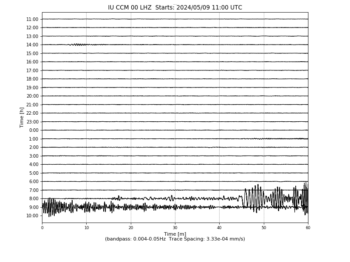

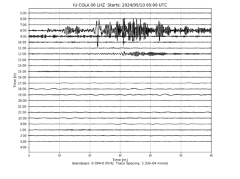
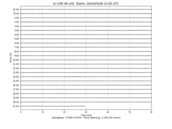
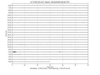
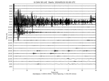

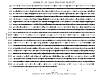

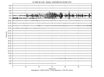

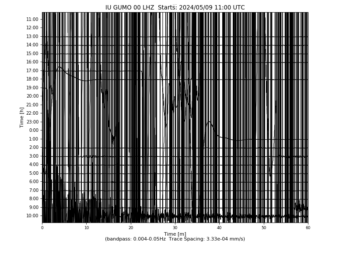
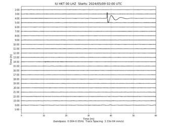
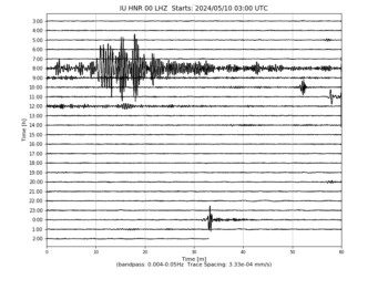


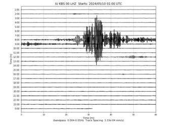
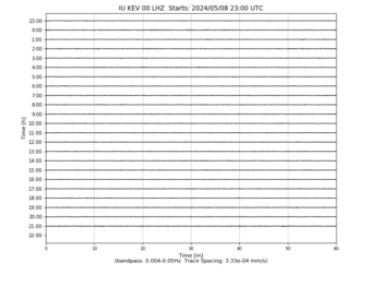
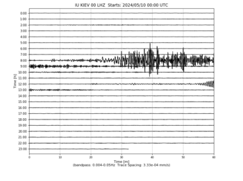


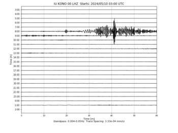

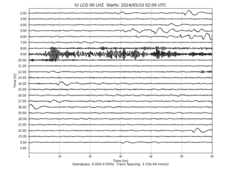


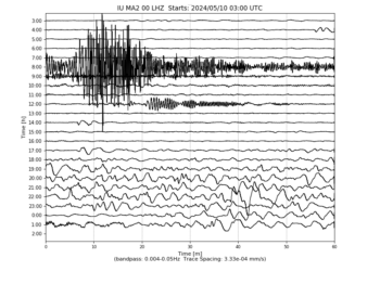

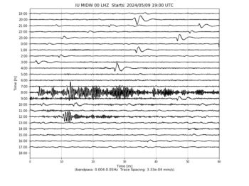


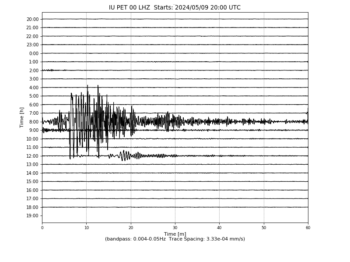
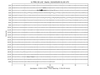
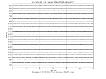

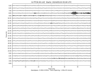

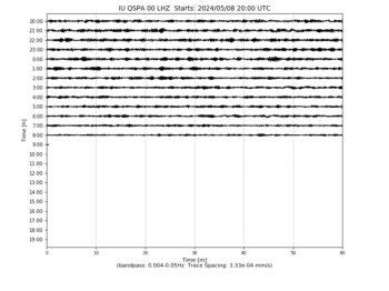
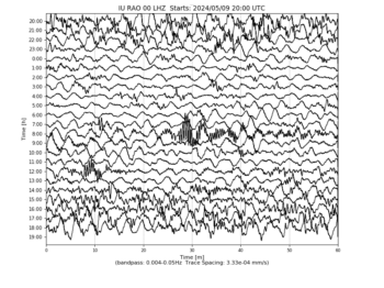
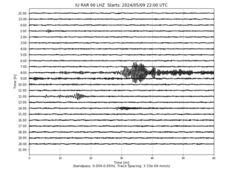
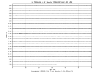
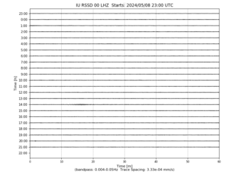

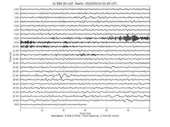
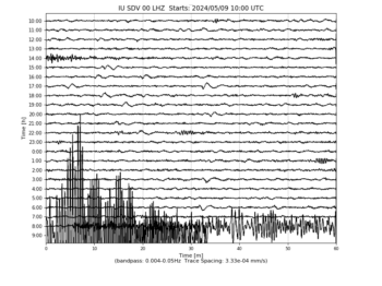
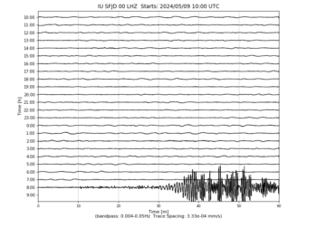
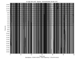

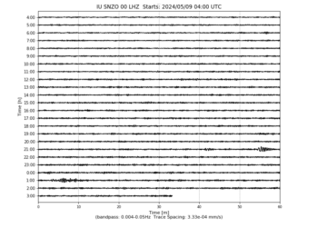
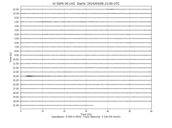
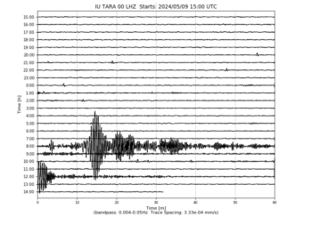
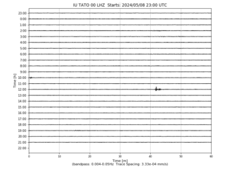
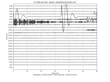
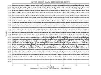

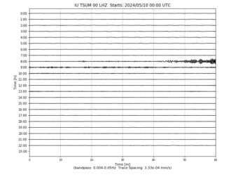
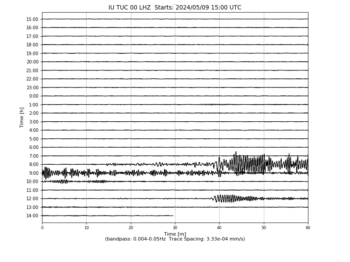
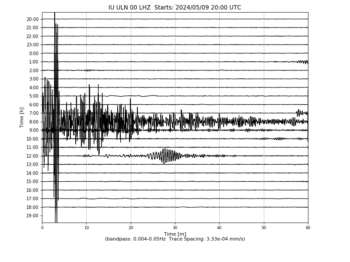

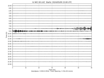
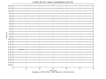


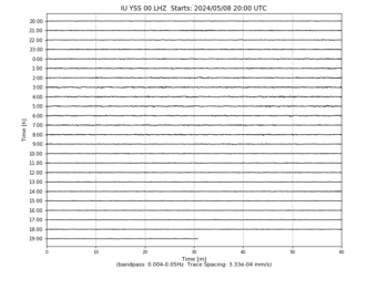
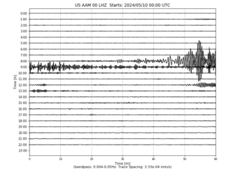
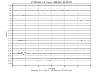
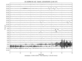
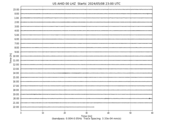
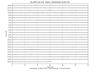
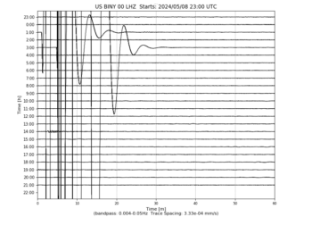
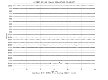
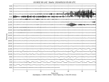
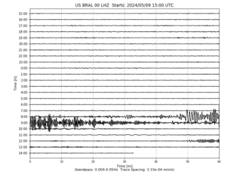

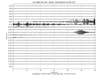
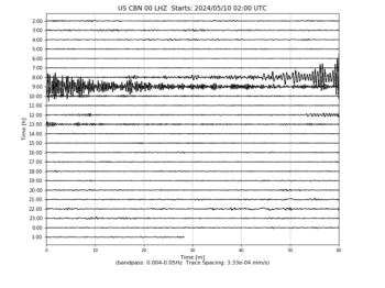


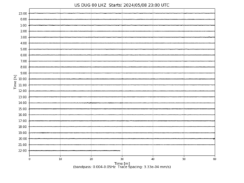
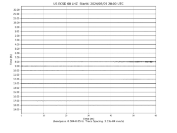
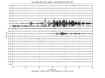
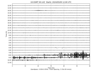
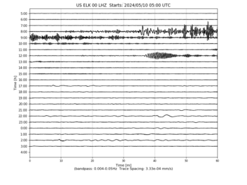
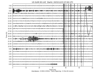
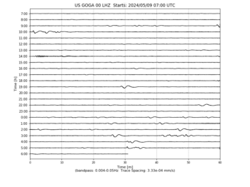
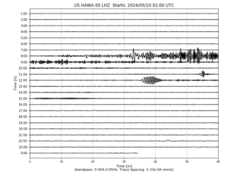
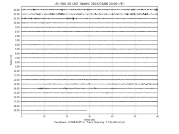

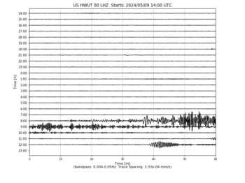

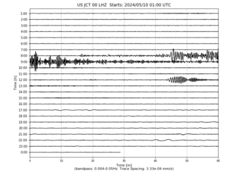
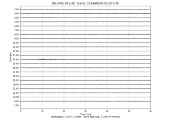
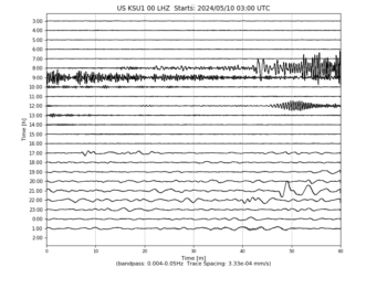
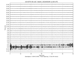
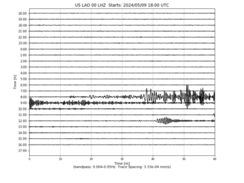
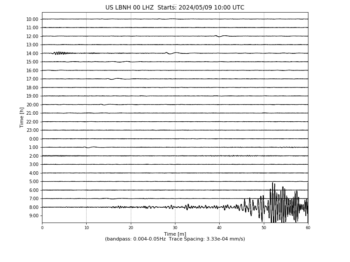

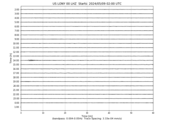
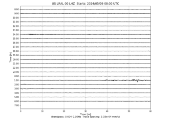
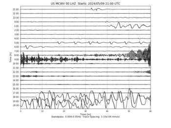
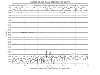
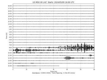

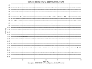
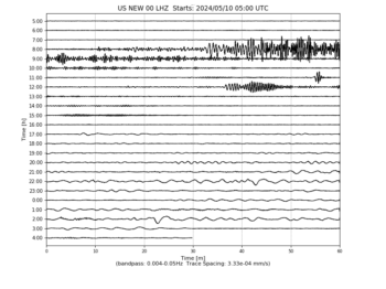
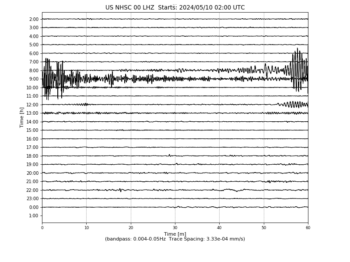
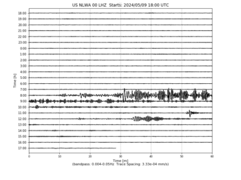
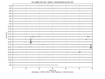


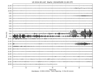
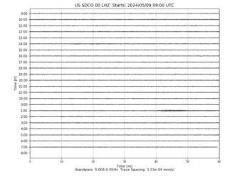

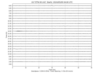
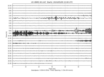


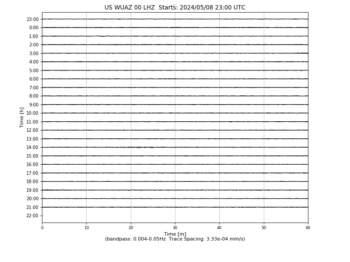
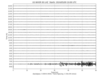
Editor’s note: On this night of the solstice… Some are saying this incoming energy wave is a psyop. Some say that while it may be showing up on computer software programs, it’s due to computer malfunction. If there aren’t energies of unknown energies continuing to arrive, why do these charts continue to show waves of unknown frequencies? Things to make you go “hmmm.”
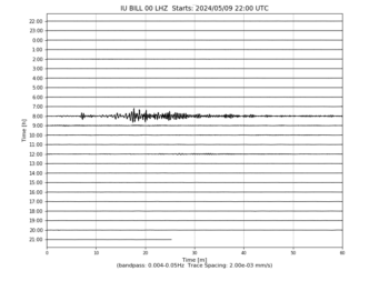
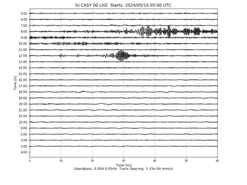
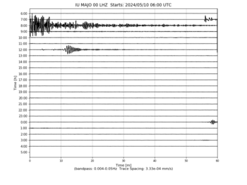
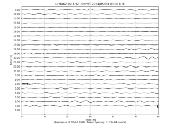
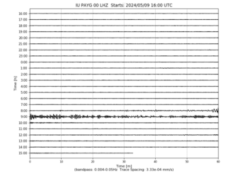
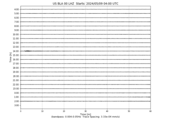
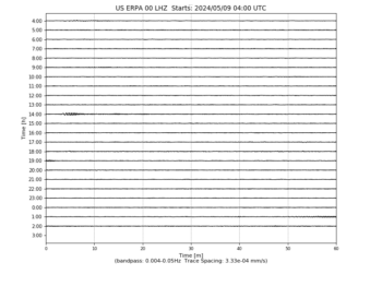
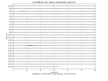
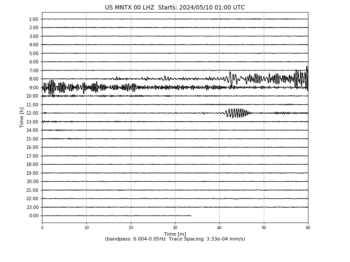
Seismograms may take several moments to load. Click on a plot to see larger image.